Published by City Farmer, Canada's Office of Urban Agriculture

Vegetable Production on Open Spaces in Dar es Salaam - Spatial Changes from 1992 to 1999
By
Stefan Dongus
dongus@gmx.de
Albert-Ludwigs-University of Freiburg/Germany
Institute of Physical Geography
Section on Applied Physiogeography of the Tropics and Subtropics (APT)
With the assistance of Ibrahim Nyika
Ministry of Agriculture & Co-operatives, Tanzania
January 2000
Urban Vegetable Promotion Project
P.O.Box 31311,
Dar es Salaam, Tanzania
e-mail: uvpp@africaonline.co.tz
Tel: 051-700947, 0812-784033
TABLE OF CONTENTS
1 PREFACE
2 ACKNOWLEDGEMENTS
3 ABSTRACT
4 INTRODUCTION AND BACKGROUND
4.1 PHYSICAL GEOGRAPHY OF DAR ES SALAAM
4.2 URBAN AGRICULTURE IN DAR ES SALAAM
4.3 OPEN SPACES IN DAR ES SALAAM
4.3.1 Definition by Dar es Salaam City Commission
4.3.2 Definition by UVPP
4.4 VEGETABLE PRODUCTION ON OPEN SPACES IN DAR ES SALAAM AND ITS IMPORTANCE
4.5 BENEFITS AND PROBLEMS OF URBAN FARMERS
5 OBJECTIVES
6 METHODOLOGY & TIME FRAME
6.1 PHASE I: FAMILIARISATION WITH THE TOPIC AND THE ONGOING RESEARCH CONCERNING VEGETABLE PRODUCTION ON OPEN SPACES IN DAR ES SALAAM (2 WEEKS)
6.2 PHASE II: ANALYSIS OF AERIAL PHOTOGRAPHS (3 WEEKS)
6.3 PHASE III: FIELD WORK (4 WEEKS)
6.4 PHASE IV: DIGITISING OF RESULTS / CREATION OF MAP (3 WEEKS)
6.5 PHASE V: DATA ANALYSIS AND WRITING OF FINAL REPORT (4 WEEKS)
6.6 AREA OF INTEREST
6.7 AGRICULTURAL PRODUCTION OF INTEREST
6.7.1 Other types of agricultural production in Dar es Salaam
7 COMMENTS ON THE METHODOLOGY
8 RESULTS
8.1 STATISTICAL RESULTS
8.1.1 Open spaces used for vegetable production in 1992 and 1999
8.1.2 Open spaces used for vegetable production in 1999, but not in 1992
8.1.3 Open spaces used for vegetable production in 1992, but not in 1999
8.1.4 Currently existing open spaces used for vegetable production
8.2 EMPIRICAL RESULTS
8.3 MAPS
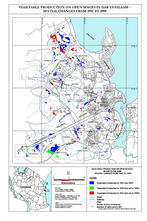
8.3.1 Map I: Vegetable Production on Open Spaces in Dar es Salaam - Spatial Changes from 1992 to 1999
8.3.2 Map I a: Currently existing open spaces used for vegetable production
8.3.3 Map I b: Newly emerged open spaces used for vegetable production
8.3.4 Map I c: Disappeared open spaces used for vegetable production
9 EXPLANATION OF THE MAPS
9.1 CONTENTS
9.1.1 Basemaps
9.1.2 Open Spaces used for vegetable production
9.2 TABULAR DATA / ATTRIBUTES
9.2.1 Attribute "category"
9.2.2 Attribute "ownership"
10 DISCUSSION
10.1 DISCUSSION OF STATISTICAL RESULTS
10.2 DISCUSSION OF EMPIRICAL RESULTS
11 RECOMMENDATIONS
12 REFERENCES
13 APPENDIX: TABULAR DATA
Footnotes have not been included in this web version.
We have included only one map in this web edition. (Click on the small version below and a large 250K version will appear.) For further detailed maps please contact the
author dongus@gmx.de
1 PREFACE
This research project was sponsored by and carried out from September 1999 to January 2000 within the Urban Vegetable Promotion Project (UVPP) in Dar es Salaam, and their various local network partners in the city (e.g. agricultural district staff, respective units in the DCC). It is part of a MSc thesis at the University of Freiburg/Germany (Institute of Physical Geography). The Urban Vegetable Promotion project is implemented under the Ministry of Agriculture and Co-operatives and supported by the German Technical Co-operation (GTZ).
The idea for this survey was brought up by the Urban Vegetable Promotion Project. The objective of the UVPP is to support urban farmers to improve vegetable production in Dar es Salaam by upgrading the extension services in town, strengthening the organisational capacity of urban farmers as well as providing general information on urban agriculture and co-operation with various stakeholders.
2 ACKNOWLEDGEMENTS
Throughout my stay in Dar es Salaam, UVPP provided me with any possible support, even in matters not concerning the research project directly. Therefore I would like to express my greatest thanks to the project's advisers Petra Jacobi and Dr. Joerg Amend, as well as Suzan Kiango, Doris Lema and all other UVPP staff.
All work related to GIS matters was done at the Dar es Salaam City Commission in the Sustainable Dar es Salaam Project (SDP), where I got access to all necessary computer equipment and any support I could think of. My special thanks go to Michael Mwalukasa (co-ordinator Managing Open Spaces, Urban Agriculture, Hazard Lands and Recreational Areas), Aisha Msonde and Joash Nyitambe (GIS Unit).
I would like to thank Prof. Dr. Camillus Sawio (University of Dar es Salaam, Department of Geography) for his fruitful comments and precious advice during the research process, as well as Dr. Pius Yanda for his assistance. Further thanks go to Dr. Mtalo at the University College of Lands and Architectural Studies (UCLAS) for his co-operation, and also to the Survey & Mapping Department in Dar es Salaam for offering me assistance.
Special thanks go to InfoBridge Consultants Ltd, namely Edwin Mugerezi (Managing Director), as well as Charles Buberwa (GIS Manager) and Josephat Kyaruzi (GIS Assistant) for their time and advice in several long sessions. Their help made it possible to solve various problems arising during GIS work.
Further thanks to Hans-Joachim Lipp (NRBZ) and Luis Waldmueller (SECAP) in Lushoto for providing GPS equipment and taking the time for a "crash-course" in GPS use, as well as to Paul Anspach from TFAP for the motorbike.
For his invaluable support over the whole period of planning and organising the project until finishing the report, I would like to thank PD Dr. Axel Drescher of the University of Freiburg (Department of Physical Geography, Section on Applied Physiogeography of the Tropics and Subtropics (APT)).
Finally, my heartfelt thanks go to Ibrahim Nyika from the Ministry of Agriculture, who was my partner during the four weeks of field work. As a team, together on a motorcycle, we visited most of the urban areas in Dar es Salaam. Without him, conversation with the urban farmers would have been impossible in most cases. Beyond the actual field work, I got to know a lot about the life and problems of urban farmers, Dar es Salaam residents, and the Tanzanian way of life. To a big part, it is due to Nyika that the field work phase was a full success and a lot of fun at the same time.
Last but not least I wish to thank Dar es Salaam's urban farmers for their co-operation and for always giving me the feeling to be welcome. I hope this work will contribute to improve their working conditions in the future. All people mentioned contributed in one way or another to make this project a success, and to make my stay in Dar es Salaam an unforgettable and pleasant experience.
Dar es Salaam, January 2000, Stefan Dongus
3 ABSTRACT
In the year 2010 half of Tanzania's population will live in urban areas, with Dar es Salaam being the most important centre of all. The city's population is estimated at 3 million people in 1999 and shows an annual growth of 7-10%. Involvement in the informal sector has become a strategy of survival for the unemployed, the low wage earners, and women without sufficient skills to secure well paid jobs. Amongst these informal sector activities, urban agriculture is chosen by a large number of residents, because it can offer employment, income and food security for the urban farmers and their families.
Market production of vegetables is taking place on open spaces all around the city. These agricultural open spaces are either privately or institutionally owned land, to which the farmers got access through formal or informal agreements with the owners. Production also takes place on public open spaces like railway reserves or under main power lines, and is currently just tolerated by the authorities.
In the past, only estimations were available about the extent of agricultural open spaces in the urban areas of Dar es Salaam. Therefore, a more scientific approach was chosen to close this knowledge gap and provide decision-makers in the city with more accurate data. Aerial photographs dating from 1992 (black & white, scale 1:12500) were analysed to identify productive open spaces. These areas were then transferred onto cadastral maps (scale 1:2500). In a third step these maps were used as base information for the field work. All identified open spaces that existed in 1992 were visited in 1999, and their size and current use was compared to the situation in 1992. During the field work also newly emerged areas were identified. The results of the aerial photographs' analysis and the field work were digitised by using Geographical Information Systems (GIS). A full inventory of agricultural open spaces including location and size is now available for planning purposes.
Almost 650 ha of the urban area of Dar es Salaam are currently used for vegetable production on open spaces, which is equivalent to 4% of the whole surveyed area, offering employment for over 4000 farmers. From these 650 ha, 12% are privately owned land, 48% are institutionally and 40% publicly owned. Caused by growing pressure on the land through increasing population, the general tendency is a decrease in area used for open space production. Over 200 ha of agricultural open spaces vanished during the last seven years. But despite this pressure, 120 ha newly emerged. This shows the viability of urban agriculture as one survival strategy for the urban poor and gives an indication about the importance and function of open space production in the urban area of Dar es Salaam.
4 INTRODUCTION AND BACKGROUND
Cities are growing because of rural-urban migration coupled with natural population growth. This can be observed particularly in almost all cities of developing countries, where the increase of population proceeds extremely fast. As a result, these cities are facing enormous problems like unemployment, growing poverty, lack of basic services and also deterioration of the environment.
The urban population's share of the total population in low and middle income countries increased from 24% in 1964 to 42% in 1989 and has been highest in Sub-Saharan Africa . Today in Tanzania 20% of all inhabitants (1999: approximately 30 million) live in urban areas . Estimations foresee that already 2010 half of the Tanzanian population will live in urban areas with Dar es Salaam being by far the most important centre of all. Dar es Salaam shows an annual population growth of 7-10%; its population is estimated at 3 million people in 1999 (Dar es Salaam City Commission) and therefore doubled in the last ten years (1988: 1,4 million) (see Table 1).
According to different statistics of international organisations (e.g. UNDP 1997, World Bank 1993), poverty is widespread in Tanzania . The Tanzanian Government claims that 39% of the urban population is poor . The dramatic growth of population is one main reason for this fact. Involvement in the informal economy has become a strategy for survival for the unemployed, the low wage earners and for women without sufficient skills to secure well paid jobs . About 56% of the urban population are absorbed by the informal sector . Urban survival strategies with regard to food production can still be regarded as a fairly unexplored field of research. One important strategy for urban dwellers to improve income and food supply is to practise urban agriculture.
| Year | Population |
| 1967* | 272.515 |
| 1978* | 843.090 |
| 1988* | 1.360.850 |
| 1992p | 2.300.000 |
| 2000p | 3.500.000 |
Table 1: Dar es Salaam Population changes over time * = Census; p = Projection based on 1978-1988 growth rates
4.1 Physical Geography of Dar es Salaam
The Dar es Salaam Region is located at 6�20' S to 7�30' S, and 39�00' E to 39�30' E. It is situated on a coastal plain which is bordered by the Indian Ocean in the east, and slopes which lead to the higher Inland Plateau in the west. Only along the arterial roads leading out of town (Bagamoyo Road, Morogoro Road, Pugu Road and Kilwa Road), the city expands also into these hilly areas.
The geological subsoil is dominated by marine limestone. The soils found in the region are mainly sandy clays and clayey sands in the coastal plain, some Rendzinas on Msasani Peninsular, whereas the soils near the edge of the plain to the Inland Plateau are coarse sands (Colluvium) . In the main river valley systems that go across the Coastal Plain (e.g. Msimbazi, Mzinga), mixed alluvial deposits (sands, silts and clays) are found. Thus the soils in Dar es Salaam Region are not particularly fertile .
In common with other coastal climates in equatorial regions, that of Dar es Salaam can be generalised as hot and humid with small seasonal and daily variations in temperature. The mean daily temperature is about 26�C, the mean seasonal range is about 4�C, and the mean daily range is about 8�C. The relative humidity reaches 100% on almost every night of the year and rarely drops below 55% during the day. The average rainfall is about 1100 mm per year with considerable variation. There is a rainy season between October and December (short rains), but the main rainy season is from March until May (heavy rains).
4.2 Urban Agriculture in Dar es Salaam
UNDP (1996) defines urban agriculture as follows:
Urban agriculture is an activity that produces, processes, and markets food and other products, on land and water in urban and peri-urban areas, applying intensive production methods, and (re)using natural resources and urban wastes, to yield a diversity of crops and livestock.
By 1988, one in five people of working age in Dar es Salaam were involved in some form of urban agriculture . Urban agriculture in Dar es Salaam includes rearing of livestock (mainly chicken and cattle), cultivation of fruit trees, but most obviously vegetable production . Vegetable production in the urban areas of Dar es Salaam takes place in homegardens or on open spaces. Homegarden production is by the number of households involved by far the most important production system in Dar es Salaam and practised throughout the whole city area. The major part of vegetables grown in homegardens is consumed by the gardeners themselves, their relatives and neighbours, and is a very important source of vitamins, whereas only few of these vegetables are sold.
Vegetable production on open spaces in Dar es Salaam (on which this research project is focussing) is mostly market oriented and therefore an important, very often the only source of income for the farmers involved .
4.3 Open Spaces in Dar es Salaam
4.3.1 Definition by Dar es Salaam City Commission
The Sustainable Dar es Salaam Programme (SDP), respectively the Dar es Salaam City Commission (DCC) uses the following classification of open spaces :
1) Utility Open Spaces:- a) Resource lands
- Mining areas
- Forest reserves
- Lakes
- Rivers and streams
- b) Urban Utility Open Spaces
- Water reservoir tank sites
- Landfills and waste disposal sites including sewerage treatment sites
- c) Flood control and drainage ways
2) Green Open Spaces
- a) Wilderness areas
- b) Protected areas
- c) Natural Parks, Urban Park areas
- d) Recreational areas
- e) Urban development Open Spaces, e.g.
- air circulation corridors in residential areas
- traffic islands and totlots
- pedestrian malls
3) Corridor Open Spaces
- a) Right of way Open Spaces
- b) Docks
- c) Public car parking areas
4.3.2 Definition by UVPP
Apparently, the SDP's definition of open spaces considers various characteristics and covers all possible kinds of land-uses, but only deals with publicly owned areas, and hence neglects private land as well as institutional areas like schools or army land. But as these areas are often used for vegetable production within the urban region of Dar es Salaam, this survey is making use of the definition by UVPP (see below). The definition by UVPP is taken from a set of definitions to describe urban production systems (e.g. homegarden production, peri-urban production). The underlying assumption for this definition is that agriculture - particularly vegetable production - is practised on the land, despite the fact that the intended "use" of it might be a different one (right of way, natural parks as indicated by DCC). The definition is therefore narrow and only applicable in the context of urban agriculture:
(Agricultural) open spaces are intra-urban production areas that are surrounded by residential, industrial or institutional areas. Open spaces are cultivated by more than one farmer, not necessarily working together as a group. Production is market-oriented. It takes place on public land (hazardous lands not suitable for construction, road reserves, available land for community use etc.) as well as private land (residential, industrial or institutional plots under-utilised or awaiting development). While public land is often farmed without official permission, use of private land depends on a formal or informal agreement with the owner. The dominating crops are vegetables.
Open spaces in Dar es Salaam are areas in close vicinity of urban settlements. In most of the cases settlements are bordering or surrounding open spaces. Up to now, the Urban Vegetable Promotion Project estimated that around 400-500 ha of open spaces are cultivated in Dar es Salaam . However, despite intensive research by various bodies, there was yet no exact figure about the actual area under cultivation. Partly this is due to flexible land-use, but also the fact that many open spaces are transitory. Another reason is that town planning very often considers only large public "open spaces" (see above) when mapping the city land-use. It was one aim of the proposed research project to fill this gap and to have a closer look at agricultural open spaces, verify the currently available estimations and feed back any new findings.
4.4 Vegetable Production on Open Spaces in Dar es Salaam and its importance
The importance of agriculturally used open spaces in Dar es Salaam's urban areas becomes obvious by the fact that more than 90% of all leafy vegetables coming to the cities' markets have their origin in the open spaces and homegardens . It is estimated that at least half of the products are coming from open spaces.
For several reasons leafy vegetables like Mchicha (Amaranthus ssp.), sweet potato leaves, pumpkin leaves, cassava leaves etc. are the main crops on urban open spaces :
- The demand is high because they are one component of the traditional meal with maize porridge (ugali).
- These leafy vegetables are very perishable and do not tolerate long transport. The closeness of the open spaces to the city markets offers the urban farmers a market niche, as farmers working outside the city cannot sell these products in the city because of the long transport distances. This means that the vegetables reach the markets in fresh condition, and also the transportation costs are low.
The importance of vegetable production on open spaces in Dar es Salaam can also be seen in the following reasons:
- It is the only source of income for a large number of people in Dar es Salaam
- Urban agriculture and especially vegetable production on open spaces contributes to the improvement of the urban microclimate, beautification of the city (urban greening) and prevention of illegal dump-sites and squatting
- Urban agriculture offers new potential for recycling urban wastes (composting)
4.5 Benefits and problems of urban farmers
Urban agriculture is one popular strategy among many survival strategies to cope with the declining standard of living in the daily life of the city's residents. Many factors facilitate the development of urban agriculture in the city. Unlike other cities Dar es Salaam still has plenty of open spaces and undeveloped plots which can be used for urban agriculture, furthermore access to water is given in large parts of the city area and all necessary inputs can be purchased in farm input supplies shops in town. Dar es Salaam is the biggest market in Tanzania and has existing bylaws for urban agriculture.
On the other hand the farmers are facing a lot of problems . One of the most important issues is land tenure. Public and private land is widely used for urban agriculture in Dar es Salaam's open spaces, but sometimes no or only informal agreements exist between the owner and the user of the land. This insecurity of land-use, the sometimes illegal use, a missing perspective regarding the period over which the land can be used makes open space production highly insecure. In most of the cases, where informal agreements to land-use exist, it is the only occupation and source of income for the family .
Another point is that regular water supply is often not provided. Many farmers depend on water from wells or rivers, with the consequence that a considerable number of open spaces are only cultivated during the rain seasons. One more constraint for urban farmers affecting transport to and from the production areas is the lack of or the bad condition of roads. It has to be the concern of the government to provide enabling frame conditions, which would be to the benefit of all residents, not only the farmers.
The main problem is that most of the city officials like politicians, city planners and other decision-makers still do not realise the importance urban food production plays as a survival strategy for the urban households. While some start to recognise and support urban agriculture, others ignore - or even try to prevent - agricultural activities . This means that more has to be done to generate the necessary knowledge to increase the awareness of these groups for this issue, in order to attain co-operation of all parties involved. Otherwise this lack of awareness could be the reason for future problems like diminishing spaces for urban agriculture for the benefit of new building sites.
5 OBJECTIVES
The main aim of the research project is to elaborate an inventory of the currently existing open spaces used for vegetable production in Dar es Salaam, but also of the open spaces used for vegetable production in 1992, including their different sizes and locations. The results will close the information gap regarding the actual area under vegetable production, the dynamic development in the last decade and thus allow to draw conclusions about the importance of this type of urban food production and its role in regard to urban food security. Furthermore, the results will contribute to a knowledge base, which can be used by town planners, city officials and policy makers to make future decisions concerning the place of urban agriculture - especially vegetable production - in the city's development. The inventory will also make it easier for support organisations to get in contact with urban farmers.
Another main aim of the research project is to raise public awareness in respect of vegetable production within the urban area of Dar es Salaam. It was intended to incorporate already existing material on Dar es Salaam's agricultural land-use (Dar es Salaam City Commission, University of Dar es Salaam, Mapping Department).
The thought behind the project is to make it possible for urban farmers to get more support from various stakeholders concerning the question of land tenure, water supply, infrastructure, extension services and training.
The medium to present the results of the survey will be a map in digital and paper form that comes with additional tabular data showing further information, created with GIS Software. This will allow to visualise the spatial distribution of vegetable production on open spaces in Dar es Salaam, but also to do further analysis like calculation of sizes. Other advantages of the digital map are that it can be combined with already existing digital data, updated in the future, and extended to a greater range of topics by other researchers, which are at the same time desirable aspects from the author's point of view.
6 METHODOLOGY & TIME FRAME
The methodology was a combination of drawing from experiences of agricultural staff and other involved institutions, analysing aerial photographs, empirical field work and finally using Geographical Information Systems (GIS) to visualise and analyse the results.
The preparation for the project took place in Germany and comprised the study of all available publications of UVPP as well as Internet research on the topic of urban agriculture (also in the world-wide context). The available period of four months for the research in Dar es Salaam was divided in five main phases:
6.1 Phase I: Familiarisation with the topic and the ongoing research concerning vegetable production on open spaces in Dar es Salaam (2 weeks)
This included field visits of several open spaces used for vegetable production, discussions with UVPP staff, meetings with different parties involved, such as the University of Dar es Salaam (Department of Geography), the Sustainable Dar es Salaam Programme (SDP), the University College of Lands and Architectural Studies (UCLAS), the Mapping Department and also a private consultancy for GIS (InfoBridge). One aim of this working phase was to get an overview of all research activities which had already taken place in this field, and to find out whether there is any existing information on the topic which might be useful for the project. Another intention was to discuss possible methodologies for the planned project to avoid mistakes resulting from lack of knowledge of the local context.
6.2 Phase II: Analysis of aerial photographs (3 weeks)
The analysis was based on the most up-to-date available set of aerial photographs of the Dar es Salaam region (black and white; scale 1:12500), taken in the first week of July 1992, two months after the end of the rain season (according to the average mean). The photographs were used in combination with a stereoscope in order to identify all open spaces used for vegetable production by the time the photographs were taken. The borders of the identified locations were transferred to the set of cadastral maps (scale 1:2500) of the Dar es Salaam region. The high resolution of the aerial photographs and the large scale of the paper maps made it possible to obtain high accuracy regarding the position of the boundary lines. Some locations were immediately visited to verify or clarify the situation, for example in the case of small sheds used to cultivate coriander (Coriandrum sativum) in Msimbazi Valley, which were not obvious to identify as agricultural production sites on the photographs. For general ground control, several accompanying field visits were done to avoid mistakes during this working phase.
6.3 Phase III: Field work (4 weeks)
The fact that the most recent complete set of aerial photographs available for the Dar es Salaam region is originating from 1992, and the lack of satellite imagery with an adequately high resolution for this area made it necessary to check the situation for 1999 by field work. The short period available for this part of the survey made it necessary to find a reasonable way to obtain as much areal coverage as possible. With a motorcycle used as means of transport, and sometimes by walking in areas of difficult accessibility, all areas identified as productive open spaces during the aerial photograph's analysis were visited by the author and Mr. Ibrahim Nyika (Ministry of Agriculture). Sites which turned out not to be accessible for checking were for example some institutional areas such as army land, or private land like some industrial areas, which were fenced by high walls. Nevertheless, even in these cases it was often possible to have a glance at the area of interest from outside, which was enough to verify that the production is still going on or to find out the opposite. Only in 4 of 352 cases the visit of such "difficult" areas had to be omitted. Unchecked areas are specially marked in the tabular data coming with the map.
In all other cases the sites were checked. The usual procedure was to find one or several farmers working at the site, and to introduce ourselves, respectively the intentions of our visit. If the farmers agreed to give us their time for a short interview, they were asked about the ownership of the site, the access to water, and in some cases for the number of farmers working at the site. The interviewing procedure was informal, in order to allow discussions about site specific problems and various concerns brought up by the farmers themselves. Finally, the extent of the site was compared to the one of 1992. This was possible only by working with the cadastral maps. In case of changes, the new situation was marked in the map. If no farmers were present at the sites (which happened mainly in rainfed production areas), only the changes in extent were checked, without obtaining further information. In two cases, Differential GPS technique was used to measure significant changes in unintelligible areas.
6.4 Phase IV: Digitising of results / creation of map (3 weeks)
Finally, the results from the aerial photograph's analysis and the field work were digitised. This was done by the use of MapInfo, which is a common Geographical Information System (GIS) Software that allows visualising and analysing geographical data, for example to calculate the sizes of all digitised areas. The final output is the map "Vegetable Production on Open Spaces in Dar es Salaam - Spatial Changes from 1992 to 1999" attached to this report.
6.5 Phase V: Data analysis and writing of final report (4 weeks)
The collected data and the results were analysed and discussed with various parties involved (e.g. Sustainable Dar es Salaam Programme, University of Dar es Salaam (Department of Geography), Urban Vegetable Promotion Project, agricultural extensionists). As the last working step, the final report was written. This was done in Dar es Salaam, to guarantee quick access to all necessary background information.
6.6 Area of interest
The area of interest for this survey is the urban area of Dar es Salaam. As the survey also considers the situation for 1992, it was necessary to restrict the survey area to the urban area as it existed in 1992. Open spaces according to the definition by UVPP can only be found in urban areas. It is very difficult if not impossible to define a line, which separates the urban from the peri-urban area . For the definition of the urban area as referred to in this report, three aspects were considered:
1) The map "Urban and Peri-Urban Agriculture in Dar es Salaam" (UVPP 1998, attached to this report), which shows the areas for urban as well as for peri-urban production. The urban area as defined in this map corresponds with the built-up area in 1992 as defined by the Dar es Salaam City Commission (DCC). This definition served as the basis for the survey, but was slightly adapted according to the next two aspects.
2) The set of cadastral maps (scale 1:2500) for Dar es Salaam region does not completely cover the area as defined above, particularly for some western regions along Morogoro Road and Pugu Road, as well as the parts of Dar es Salaam south of Yombo River. As these maps were indispensable for the survey, the area of interest had to be restricted to the area covered by the maps.
3) The areas north of Mbezi River (Mbezi) and west of the harbour (Kigamboni) were not considered as urban area. The aerial photographs from 1992 revealed that at this time these areas had strong peri-urban characteristics. Although being built up, low-density settlements were dominating, combined with intensive homegarden production. Open spaces in the sense of the survey were not existing. Sites located in between built-up areas, such as the Msimbazi Valley between Vingunguti and Tabata, were included in the survey although they are not marked "urban" in the DCC's map. These areas, all of them river valleys entering Dar es Salaam urban area wedge-shaped from the west, are important green belts for urban residents and also partly used for vegetable production (also rice production). In all other cases, the area of interest corresponds with the DCC's definition in 1).
6.7 Agricultural production of interest
The survey was focussing on vegetable production on open spaces. The crops considered in the survey were all kinds of leafy and non-leafy vegetables. The most common leafy vegetables cultivated in Dar es Salaam are:
- african spinach (Amaranthus ssp., "mchicha")
- sweet potato leaves (Ipomea batatas)
- pumpkin leaves (Curcubita moschata)
- cassava leaves (Manihot esculenta)
- cowpea leaves (Vigna unguiculata)
- swiss chard (Beta vulgaris var. cicla)
- chinese cabbage (Brassica chinensis)
- african kale (Brassica oleravea var. acephala)
- nightshade (Solanum scabrum)
- tomato (Lycopersicon esculentum)
- eggplant (Solanum melongena)
- african eggplant (Solanum macrocarpon L)
- sweet pepper (Capsicum spp.)
- hot pepper (Capsicum frutescens)
- okra (Hibiscus esculentus)
- cucumber (Cucumis sativus)
- carrot (Daucus carota)
The minimum size of open spaces considered in this survey was 1000m2. In cases where several smaller production sites were separated through roads etc., the size was calculated by adding the single sizes. All areas smaller than 1000m2 were not included in the map and are therefore referred to as homegardens.
6.7.1 Other types of agricultural production in Dar es Salaam
This survey concentrated only on open space production of vegetables, nevertheless a variety of other production systems do exist in Dar es Salaam, using urban land for agricultural purposes. These are: Rice production, cultivation of fruit trees, cultivation of maize and livestock keeping. Homegardening was also not considered in this survey. Homegardening is in terms of the number of farmers involved by far the most important type of vegetable production in Dar es Salaam. Homegardens are found in almost all areas of the city, producing mostly for the households themselves . In contrast to open space production, homegardening is commonly practised by women. Sometimes the size of homegardens is only a few square meters , which made it impossible to conduct a similar survey for the extent of homegarden production for the whole city area.
Rice production is widespread in the urban area of Dar es Salaam. Especially the river valleys provide good frame conditions in this respect. During rain season, a lot of farmers are growing rice, although the possibilities for income cannot compete with vegetable production. Up to now there is no accurate data about the extent of rice production in the urban areas of Dar es Salaam. However, estimations of the area under rice cultivation do exist on district and regional level, covering both urban/mixed and rural wards.
Fruit trees (mainly papaya, coconut, citrus, mango, cashew) and banana can be found all over Dar es Salaam urban area. Especially banana and papaya trees are often integrated in urban vegetable production systems, homegardens as well as open spaces. The same applies to maize, but only on a minor level. Areas exclusively used for maize production were not included in the survey.
A quite controversial type of agriculture is livestock keeping in close vicinity to urban settlements. Cattle, goats and chicken are grazing along the streets in the city, causing disturbances such as unpleasant odours or destruction of crops (mainly by goats), but at the same time providing an important source of income for the owners. Aquaculture is not of relevance in the case of Dar es Salaam, which is probably resulting from the location next to the Indian Ocean.
7 COMMENTS ON THE METHODOLOGY
This chapter refers to the different working phases as explained in Chapter 6.
After discussing with all involved parties, it turned out that no comparable work had been done up to now, not even for selected parts of Dar es Salaam. Therefore it was not possible to refer to already existing data, which would have saved a lot of efforts.
A tricky task concerning the aerial photographs' analysis was to distinguish between completely abandoned former production sites and temporarily lying fallow sites, which are under production during the rain seasons. The only way to clarify this uncertainty was by field-check or, respectively, by interviewing farmers. Sometimes also difficult to identify were cassava plantations, because they often had no typical linear pattern and therefore resembled bushy areas.
The chosen method for the field work turned out to be very effective for the case of Dar es Salaam. It was no problem to address the farmers directly, even without previously getting the permission of the various ward leaders to conduct research work in the region of their responsibility. This would probably have been different, if more technical equipment was used for measuring the sites. But as only maps and simple observation were applied, there was no distrust on behalf of the farmers. Some farmers reacted rather reserved when we arrived at a site (which appears to be a logical reaction, considering that the farmers sometimes do not have any official permission to use the land for agricultural purposes), but after introducing our purpose and profession, we were always welcome. This enabled us to visit all productive open spaces identified on the aerial photographs without choosing representative areas. For the two sites that were measured by GPS technique, the ward leaders were informed and permitted us to continue our work. Although being very precise, the Differential GPS technique turned out to require a big amount of time and effort, particularly when it came to downloading and computing the collected data. On the other hand it was not really necessary, because in almost all cases, having a closer look at the sites in combination with studying the very detailed and accurate cadastral maps was sufficient to decide about the situation. The decision of trying to start the field survey without previously informing all ward leaders was also taken in consideration of the necessary amount of time this would require.
A difficult task was to find new open spaces used for vegetable production. As it was impossible to survey the whole urban area within 4 weeks, the discoveries of new production sites were restricted to the areas that were passed while checking the sites identified for 1992. In addition, seemingly suitable areas for production which were not producing in 1992 were checked, for example the railway reserve along the Central Railway line.
The decision to work with MapInfo Software instead of ArcView (which is more or less the standard software) had several reasons: First, there were compatibility problems with the base maps available in ArcView format and the cadastral maps (UTM grid system), from which the digitising work had to be done. Second, all institutions involved in GIS work in Dar es Salaam have MapInfo installed on their computers, all necessary data in digital form was available in MapInfo format and no compatibility problems were showing up. After finishing GIS work with MapInfo, it was possible to export the new data to all other standard GIS, including ArcView. Therefore all interested parties can use the results of the survey in future times.
8 RESULTS
8.1 Statistical results
8.1.1 Open spaces used for vegetable production in 1992 and 1999
177 open spaces covering a total area of 520 ha have not been subject to any changes in land-use during the past seven years. The major part of these 520 ha is owned by institutions (53%) , 35% are publicly owned and 12% privately. Most of this area is army land (31%), the rest is located in between settlements (24%), along river valleys (15%), in industrial areas (13%), along railway lines (7%) and along main power lines (4%). 27 schools in Dar es Salaam grow vegetables, but as these open spaces are quite small, they only make up 3% of the overall area. The share of rainfed and irrigated areas is almost equal.
8.1.2 Open spaces used for vegetable production in 1999, but not in 1992
59 agricultural open spaces covering a total area of over 120 ha have newly emerged in the last seven years, the largest part on publicly owned land (63%). 24% of these 120 ha are institutionally owned land, 12% private property. Most of newly emerged areas can be found in settlements (37%) and along railway lines (20%), followed by the river valleys (18%). 28% of the new productive open spaces are irrigated, the remaining 72% are used during the rain seasons only. There might be even more newly emerged open spaces, which were not discovered during the field survey.
8.1.3 Open spaces used for vegetable production in 1992, but not in 1999
Over 200 ha of formerly cultivated open spaces, divided in 116 different sites, are not used for vegetable production anymore. The highest quantity of �disappeared" open spaces, covering an area of 63 ha, is located in settlements. Reasons for the disappearance of productive open spaces are water shortages, plantation of trees, problems with goats and chicken deserting the seedbeds , but most of all the construction of new buildings (47% of total abandoned area). For the latter reason, almost 60 ha of productive open spaces vanished in industrial areas and river valleys. Although not being built up until now, over 60 ha of formerly productive open spaces are not cultivated anymore on army land. These areas were used for rainfed vegetable production in 1992, but are lying fallow today and are partly covered with bushes. The reasons for the abandonment are not clear in this case. 33% of the areas that are not cultivated anymore are private land, 53% belong to institutions, and only 14% are publicly owned.
| . | Open spaces used for vegetable production in 1992 and still in 1999 | Open spaces used for vegetable production in 1999, but not in 1992 | Open spaces used for vegetable production in 1992, but not in 1999 |
|---|---|---|---|
| whole urban area | 518 ha (177)* | 123 ha (59) | 206 ha (116) |
| Kinondoni district | 261 ha (88) | 25 ha (19) | 129 ha (62) |
| Ilala district | 120 ha (57) | 44 ha (27) | 55 ha (31) |
| Temeke district | 137 ha (32) | 54 ha (13) | 22 ha (23) |
| privately owned | 61 ha (32) | 15 ha (09) | 68 ha (53) |
| institutionally owned | 276 ha (77) | 30 ha (20) | 109 ha (37) |
| publicly owned | 181 ha (68) | 78 ha (30) | 29 ha (26) |
| road reserves | 4 ha (11) | 3 ha (05) | 2 ha (05) |
| railway reserves | 34 ha (14) | 25 ha (13) | 1 ha (02) |
| power lines | 20 ha (09) | 7 ha (03) | 4 ha (02) |
| primary schools | 15 ha (25) | 2 ha (05) | 10 ha (15) |
| secondary schools | 2 ha (02) | 7 ha (01) | 2 ha (01) |
| university | 10 ha (05) | - | - |
| army land | 163 ha (18) | 10 ha (08) | 67 ha (07) |
| river valleys | 79 ha (39) | 22 ha (11) | 28 ha (18) |
| industrial area | 67 ha (10) | 1 ha (01) | 29 ha (19) |
| settlements | 124 ha (44) | 46 ha (12) | 63 ha (47) |
| irrigated | 265 ha (83) | 35 ha (27) | - |
| rainfed | 253 ha (94) | 88 ha (32) | - |
Table 2: Most important statistical results of the survey * the numbers in brackets denote the respective numbers of open spaces
8.1.4 Currently existing open spaces used for vegetable production
Combining the new agricultural open spaces from 1999 (see 8.1.2) with the open spaces that were producing in 1992 as well as in 1999 (see 8.1.1), one obtains the currently existing productive open spaces.
Almost 650 ha of the urban area of Dar es Salaam are currently used for vegetable production on open spaces. The size of the urban area of Dar es Salaam as defined in the map is 165 km2. Therefore, the percentage of the area used for vegetable production today is almost 4% of the urban area. 48% of these 650 ha are institutionally owned, 40% publicly and 12% privately. 53% (almost 350 ha) are depending on rain, the remaining 300 ha are irrigated. Based on the collected data, the author agrees with the UVPP�s estimation that the average plot size cultivated by one farmer is 700-950 m2 on irrigated open spaces. For rainfed open spaces, the average plot size is considerably higher (4000-5000 m2). This means that over 4000 farmers are working on Dar es Salaams productive open spaces.
The major share of today's productive open spaces in Dar es Salaam's urban area is situated in between settlements (27%), on army land (27%), and along the river valleys (16%). 11% of the open space production takes place in industrial areas, 9% along railway lines. The two largest agricultural open spaces are the Jet Club area near the airport (>90 ha) and the army land in Kawe/Makongo (>100 ha).
The map reveals that most of the productive open spaces are located along rivers . Other accumulations of open spaces are along the railway lines, especially near Tazara Station and along the Central Railway Line between Vingunguti and Ukonga. High density residential areas like Manzese, Mabibo or Vingunguti only show a small quantity of open space production; homegarden production is dominating. In the city centre (Kivukoni, Kariakoo, Upanga), open space production is not existing. Apart from the regions mentioned above, the productive open spaces are more or less equally scattered over the whole area of interest.
| whole urban area | 641 ha (236)* |
| Kinondoni district | 286 ha (107) |
| Ilala district | 164 ha (84) |
| Temeke district | 191 ha (45) |
| privately owned | 76 ha (41) |
| institutionally owned | 306 ha (97) |
| publicly owned | 259 ha (98) |
| road reserves | 7 ha (16) |
| railway reserves | 59 ha (27) |
| power lines | 27 ha (12) |
| primary schools | 17 ha (30) |
| secondary schools | 9 ha (03) |
| university | 10 ha (05) |
| army land | 173 ha (26) |
| river valleys | 101 ha (50) |
| industrial area | 68 ha (11) |
| settlements | 170 ha (56) |
| irrigated | 300 ha (110) |
| rainfed | 341 ha (126) |
Table 3: Currently existing open spaces used for vegetable production * the numbers in brackets denote the respective numbers of open spaces
8.2 Empirical results
Observations during the field work phase and discussions with various urban farmers made it possible to obtain insights into the situation of the farmers from their point of view. The most common complaints to be heard were dealing with the lack and/or the poor quality of water, the problem of land tenure and the lack of sufficient services to create knowledge concerning the improvement of production techniques.
Many farmers requested better water infrastructure like wells or pumps. In most cases, where water for irrigation is available, it has to be carried in watering-cans, which is only possible for a certain distance. Only few urban farmers have access to tap water. Very often, farmers were complaining about the quality of the water for irrigation. Examples for this are all areas along Ruhanga river, but especially the Msimbazi valley . Various tests show indeed that this water is not of drinking water quality, which is due to the lack of sewage systems both for households and industries. But in most of the cases, the concentration of heavy metals as well as organic material is apparently low enough to use the water for irrigation without any health risks for consumers. The pollution with wastewater from households was easy to identify by the typical smell, and in one case the water of Ruhanga river (which is apparently polluted by industrial wastewater, e.g. from Urafiki Textile) changed its colour from dark green to bright red within 30 minutes. In the latter case, the farmers try to avoid the direct use of this water by digging ditches several meters besides the actual river, which makes it possible to get water slightly cleaned through infiltration.
Insecure land tenure on public as well as private and institutional land was frequently observed. Sometimes, farmers only dare to grow short-cycled crops, fearing the loss of their farm land in near future. Remarks on behalf of the farmers, regretting that the actual owner will soon build up the land they are farming, were not isolated cases.
The author and his partner were asked by almost all interview partners to forward their request for services and advice in regard to production techniques to the Dar es Salaam City Commission, the Ministry of Agriculture and support organisations like the UVPP. The production on sites which are already co-operating with agricultural extensionists all seemed to be in relatively good state of maintenance, whereas other areas might bear more potential as currently used. Remarkably, even relatively large open spaces with many farmers often had no organisation in form of farmer groups. In opposition, very often there seemed to be only little communication between farmers on one site.
Pests and diseases are a widespread problem, even though most of the farmers only complained about this issue after being asked directly about specific problems they have with it. It was observed that the knowledge about diseases, pests and pest control is very low. One obvious result of this lack of knowledge is the use of unsuitable remedies, for example domestic pesticides against diseases.
Soil fertility did not seem to be a problem in the point of view of the farmers. There were no complaints in respect of the soil quality, even though the sandy soils in Dar es Salaam do not provide ideal conditions for vegetable production. Remarkably, there was no request for any machinery on behalf of the farmers.
A common sight in Dar es Salaam is rubbish in the streets of the high-density areas and along the roadsides throughout the city. But all visited agricultural open spaces were kept clean from rubbish. The same observation was made in regard to homegardens.
8.3 Maps
We have included only one map in this web edition. For further detailed maps please contact the
author dongus@gmx.de
9 EXPLANATION OF THE MAPS
This chapter gives explanations of the map �Vegetable Production on Open Spaces in Dar es Salaam - Spatial Changes from 1992 to 1999" (A3 size). The three other maps in A4 size are based on the same system, which means that the necessary background information for all maps can be derived from this chapter. These maps only show a specific selection of areas, which are all included in the main map. For reasons of perspicuity, the ID-labels in the main map (A3) only cover the open spaces used for vegetable production in 1992 as well as 1999 (1-177). The ID-labels for newly emerged (178-236) and disappeared productive open spaces (237-352) can be deduced from the respective maps in A4 size.
9.1 Contents
9.1.1 Basemaps
The layout of the map was produced exclusively by using MapInfo GIS. The basemaps had to be in UTM grid format, as the cadastral maps were also in this grid format. For Dar es Salaam region, only few digitised map material exists. The finally chosen basemap only contains the roads and railway lines of Dar es Salaam urban area (scale 1:20000) and was produced by InfoBridge Consultants Ltd. All rivers as well as the shoreline of the Indian Ocean were digitised by the author.
9.1.2 Open Spaces used for vegetable production
The map itself contains three kinds of productive open spaces, which are marked in different colours:
- 1) Open spaces which were used for vegetable production in July 1992 (as seen on the aerial photographs) and still in November 1999 (as seen during the field check)
- 2) Open spaces which were used for vegetable production in 1999, but not in 1992
- 3) Open spaces which were used for vegetable production in 1992, but not in 1999
9.2 Tabular data / attributes
Apart from the information given by the map itself, additional tabular data (see appendix) reveals further information on each area marked in the map. The attributes are:
| Attribute | Explanation |
|---|---|
| ID | Identification number (of every single productive open space) |
| sheet | Number of the sheet (cadastral map 1:2500) on which the area is located |
| location | Name of the ward in which the area is located |
| municipality | Name of the municipality in which the area is located |
| category | see below (9.2.1) |
| ownership | see below (9.2.2) |
| type | Either irrigated (production throughout the whole year) or rainfed (production only during the rain seasons). In cases where both types of production occurred on a site, the dominating type is marked and a comment is added at the attribute "remarks" |
| water | Source of water, only in cases where the area is irrigated |
| status | Status of production (according to the numbering in 9.1.2) |
| size | Size of the area (in square meters) |
| farmers | Number of farmers working in the area (if known) |
| reason | Reason for disappearance in 1999 (if known) |
| remarks | Further information |
9.2.1 Attribute "category"
Each productive open space has been assigned to a certain category, according to the specific characteristics of the area. The categories are:
- road reserve: areas on both sides of roads which are reserved for further road construction activities (right of way open space)
- railway reserve: areas on both sides of railway lines which are reserved for further construction activities or safety zones (right of way open space)
- power lines: areas under main power lines, where any construction activity is prohibited
- primary school: areas belonging to primary schools, mainly used for educational purposes
- secondary school: areas belonging to secondary schools, mainly used for educational purposes
- university: areas belonging to the University
- army land: areas belonging to the army
- river valley: areas on both sides of rivers, most of them in valleys; slopes of river valleys are also included; the big river valley systems (Msimbazi, Mzinga) are hazard land according to the DCC, therefore publicly owned and not suitable for construction purposes
- industrial area: areas surrounded by industry
- settlement: areas surrounded by settlements, which do not match any of the other categories
9.2.2 Attribute "ownership"
In general, the ownership of all open spaces is either private or public. Nevertheless, institutional ownership (which is also private) was marked separately. Privately owned open spaces are found in residential (planned and unplanned) and industrial areas, and some small river valleys which are not suitable for construction. Institutionally owned open spaces are areas belonging to schools, university, churches, cemeteries, hospitals, public offices/buildings and army. Publicly owned open spaces comprise road reserves, railway reserves, the areas under main power lines, the big river valley systems (Msimbazi, Mzinga) and all other areas which fall under the SDP's definition of open spaces (see 4.3.1)
10 DISCUSSION
10.1 Discussion of statistical results
650 ha of the urban area of Dar es Salaam, which is equivalent to 4% of the surveyed area, are currently used for vegetable production on open spaces. This is an important source of income for over 4000 farmers. Over 200 ha of productive open spaces vanished during the last seven years, which is mainly caused by growing pressure on the land through increasing population. This is shown by the fact that half of the disappeared area is built up in the meantime. But despite this pressure, over 120 ha of agricultural open spaces newly emerged, and over 500 ha were not subject to any changes since 1992. This shows the viability of urban agriculture as one survival strategy for the urban poor, and gives an indication about the importance and function of open space production in the inner city of Dar es Salaam. Nevertheless, the general tendency is a decrease in area used for open space production.
Most of the vegetables harvested on Dar es Salaam�s open spaces are sold on the city�s markets or privately. They are an important component of the supply with vegetables both on the household and on the city level. This is particularly true for leafy vegetables, which do not tolerate long transport. Therefore, urban vegetable production is contributing to urban food security.
Open space production is not the only agricultural activity in the urban area of Dar es Salaam. The aerial photographs and the experiences gained in the field show that livestock keeping, rice production, cultivation of fruit trees, bananas and maize as well as homegarden production are other important types of agriculture in the city, although they are not included in this survey.
In relation to all identified open spaces, the two main open spaces (Jet Club near the airport and army land in Kawe/Makongo) cover a very large area and have a substantial influence on the statistical data. The following consideration might illustrate this: 47% of the area that was used for vegetable production in 1992, but not anymore in 1999, is built up. But by neglecting the army land in Makongo, where over 60 ha of agricultural production have been abandoned without being built up, the percentage of built-up area would be significantly higher (almost 70%).
10.2 Discussion of empirical results
Wells were even requested by farmers on sites bordered by rivers, where the ground water level is high. Apparently, these farmers were not in the position or willing to dig their well themselves. Several times it was observed that farmers were using domestic pesticides to deal with pests or even diseases of their crops. This reveals an obvious lack of knowledge, ideas and self-help initiatives. The use of unsuitable remedies like domestic pesticides is a potential threat to the health of consumers, as well as inappropriate use of principally recommendable remedies, for example in wrong doses or too short before harvesting.
Although the whole Msimbazi valley is officially declared as �hazard land" by the Dar es Salaam City Commission, therefore publicly owned and not suitable for construction, many people built (illegal) houses in the valley, for example between Tabata and Vingunguti, where several productive open spaces are lined up along the river . The illegal settlements that entered the valley in this part did not affect the agricultural open spaces (which already existed in 1992), new buildings are directly bordering them, but almost all production sites remained untouched. This shows that urban agriculture can prevent squatting on open spaces, and gives another indication about the importance of vegetable production on open spaces.
Vegetable production in the urban area of Dar es Salaam helps to keep open spaces free of rubbish and therefore contributes to the beautification of the city. It can also have positive effects on the air quality, the urban microclimate and therefore the general environmental perception of the residents. Urban agriculture offers an opportunity for the recycling of organic waste material. By composting it, it can be used to improve the nutritional status of the soil.
11 RECOMMENDATIONS
The results of the survey illustrate the importance of urban agriculture and particularly vegetable production on open spaces for the future development of Dar es Salaam. Urban farmers require the support from all stakeholders.
- The Dar es Salaam City Commission (DCC) should legalise agricultural land-use on public open spaces like railway and road reserves. These areas serve as buffer zones and cannot be used for construction purposes anyway. Allowing urban farmers to cultivate these areas would offer them better perspectives to plan for their future.
- Another important task for the DCC that is of relevance for all citizens, not only the farmers, is to take effective measures against the pollution of water. Sewage disposal plants are one way to attain better water quality, but in the first place, industries should be forced to dump their wastewater in an environmentally consistent manner. Dumpsites next to rivers like the one in Vingunguti (Msimbazi valley) have to be prohibited.
- Hazard lands according to the DCC, like the Msimbazi valley, which are flooded regularly and are therefore not suitable for construction purposes, offer good perspectives for urban agriculture (vegetable and rice production, livestock keeping). Provided that the water used for irrigation is clean, such areas should be designated regions for agricultural land-use. In addition, particularly on the slopes, suitable trees should be planted in regard to erosion problems . Another way to avoid erosion on the slopes would be agricultural production on terraces.
- The DCC should consider urban agriculture as one effective way of waste management. Composting offers an easy and useful possibility of recycling organic waste. The DCC should also take into account that urban agriculture is a strategy to avoid illegal squatting on open spaces, and to keep open spaces free from pollution with rubbish.
- Town planners should decide about the place of urban agriculture in the future development of the city, considering the results of this survey.
- The Ministry of Agriculture and Co-operatives should provide more support for urban farmers.
- The same applies to the districts. One way of supporting urban farmers is the provision of extension services. The map should be used in order to approach urban farmers on identified open spaces, which have not received any support in the past.
- Agricultural support organisations like the UVPP should extend their capacities and efforts in order reach more urban farmers. It should also be tried to integrate as many homegarden farmers as possible in farmer trainings.
- The urban farmers themselves should address relevant agencies for services. Furthermore, it should be in their own interest to establish more self-help initiatives and organise themselves in groups.
Recommendations for further research activities:
- The further development concerning spatial changes of open space production should be monitored in order to assess interventions. This requires a repetition of the status inventory in a few years.
- More research should be conducted on homegardens in Dar es Salaam to gain further information about its importance not only on the household level, but also on the city level. Already existing case studies in combination with field surveys in representative areas or new remote sensing data could be used as a basis to estimate the overall area used for homegarden production in Dar es Salaam.
12 REFERENCES
AMEND, J. & E. MWAISANGO (1998): Status of Soil Contamination and Soil Fertility - The Case of Urban Agriculture in Dar es Salaam. Urban Vegetable Promotion Project, Dar es Salaam, Tanzania (unpublished).
BARGMAN, D.J. (1970): The climate of Dar es Salaam. In: Dar es Salaam - City, Port and Region. Tanzania Notes and Records, 71. Dar es Salaam, Tanzania.
BARUTI, P. et al. (1992): Environmental Profile of the Metropolitan Area Dar es Salaam, UNDP/URT/90/033.
BONHAM-CARTER, G.F. (1994): Geographic Information Systems for Geoscientists: Modelling with GIS. Ottawa, Canada.
BRAUN, J.v., J. MACCOMB & B.K. FRED-MENSAH (1993): Urban food insecurity and malnutrition in developing countries: trends policies and research implications, IFPRI, Washington, USA.
BUITEN, H.J. & J. CLEVERS (1993): Land observation by remote sensing: theory and applications. Amsterdam, Netherlands.
BURRA, M. (1997): Land use and development dynamics in the peri-urban zones of Dar es Salaam city - a quest for planning and management responses. J. Building and Land Development Vol. 4, No. 2, 21-27.
BURROUGH, P.A. & R.A. McDONNELL (1998): Principles of Geographical Information Systems. New York, USA.
CAMPBELL, J.B. (1987): Introduction to Remote Sensing. New York, USA.
DRESCHER, A.W. (1996): Management Strategies in African Homegardens and the Need for new Extension Approaches. Proceedings of the International Symposium on Food Security and Innovations - Successes and Lessons learned. In: Heidhues, F. & A. Fadani: Food Security and Innovations - Successes and Lessons learned, 231-246. Frankfurt, Germany.
DRESCHER, A.W. (1998): Hausgaerten in afrikanischen Raeumen - Bewirtschaftung nachhaltiger Produktionssysteme und Strategien der Ernaehrungssicherung in Zambia und Zimbabwe (African Homegardens - Management of Sustainable Production Systems and Strategies of Food Security). Soziooekonomische Prozesse in Asien und Afrika, 4. Centaurus. Pfaffenweiler, Germany.
DRESCHER, A.W. & D. IAQUINTA (1999): Urban and Peri-Urban Food Production: A new challenge for the Food and Agriculture Organisation (FAO) of the United Nations. FAO, Rome, Italy.
FAO (1999): The "COAG-Paper". Report of the COAG Secretariat to the COAG. FAO, Rome, Italy.
IAQUINTA, D. & A.W. DRESCHER (1999): Defining peri-urban: Towards Guidelines for understanding rural-urban linkages and their connection to institutional context. Land Tenure Bulletin, FAO, Rome, Italy.
IDRC (1998): Cities Feeding People Programme. International Development Research Centre (IDRC), Ottawa, Canada. (http://www.idrc.ca)
JACOBI, P. & J. AMEND (1997): Vegetable farming in Dar es Salaam: an important source of income, and not only for the poor. agriculture + rural development, Volume 4. No. 2/97, 52-54.
JACOBI, P. (1997): Importance of Vegetable Production Systems in Dar es Salaam, Tanzania. Urban Vegetable Promotion Project, Dar es Salaam, Tanzania (unpublished).
JACOBI, P. (1998): Food Production as a Survival Strategy for Urban Households - State of knowledge and state of research in Tanzania. Urban Vegetable Promotion Project, Dar es Salaam, Tanzania (unpublished).
JACOBI, P.; J. AMEND & S. KIANGO (1999): Case Study about the Situation of Urban Agriculture in Dar es Salaam. Urban Vegetable Promotion Project, Dar es Salaam, Tanzania (unpublished).
KIANGO, S. & T. LIKOKO (1996): Vegetable Production on Open Spaces in Dar es Salaam, Tanzania. Urban Vegetable Promotion Project, Dar es Salaam, Tanzania (unpublished).
KOGI-MAKAU, W. (1998): Production and Utilisation of Vegetable and Fruits in two Urban Sites in Dar es Salaam. A case study in Mbuyuni and Manzese, Dar es Salaam, November 1995 to November 1996. Urban Vegetable Promotion Project, Dar es Salaam, Tanzania (unpublished).
KYESSI, A. (1997): City Expansion and urban agriculture in Dar es Salaam: Lessons for planning. J. Building and Land Development Vol. 4, No. 2, 28-37.
MASCARENHAS, O. (1994): Trends in Urban Poverty Research in Tanzania. Paper presented in a workshop on: The Governance of Urban Development in Tanzania, August 1994.
MLOZI, M.R.S. (1998): Urban vegetable production in low-density areas of Dar es Salaam Metropolis. Urban Vegetable Promotion Project, Dar es Salaam, Tanzania (unpublished).
MOUGEOT, L.J.A. (1994): Urban Food Production: Evolution, Official Support and 7Significance (with special reference to Africa). CFP Report Series, Report 8. International Development Research Centre (IDRC).
MUSTER, G. (1997): Environmental Problems of Urban Agriculture - A case study of Dar es Salaam, Tanzania. Urban Vegetable Promotion Project, Dar es Salaam, Tanzania (unpublished).
MVENA, Z.S.K., I.J. LUPANGA & M.R.S. MLOZI (1991): Urban Agriculture in Tanzania: A study of six towns. Sokoine University of Agriculture, Morogoro, Tanzania.
NUGENT, R.A. (1997): The Significance of Urban Agriculture. Published by City Farmer, Canada's Office of Urban Agriculture. (http://www.cityfarmer.org/racheldraft.html#racheldraft)
OYIEKE, T.O., T. NNKYA & B. KOFI DOE (1997): Evaluation report, Phase II of Sustainable Dar es Salaam Project. Dar es Salaam, Tanzania (unpublished)
RUAF (1999): Summary of the Programme Proposal. Resource Centre On Urban Agriculture and Forestry (RUAF). Published by City Farmer, Canada's Office of Urban Agriculture. (http://www.cityfarmer.org)
RUEL, M.; L. GARRETT, S. MORRIS, D. MAXWELL et al. (1998): Urban challenges to food and nutrition security: A review of food security, health, and caregiving in the cities. Food Consumption and Nutrition Division. International Food Policy Research Institute (IFPRI). Washington, USA.
SAWIO, C.J. (1994): Urban Agriculture and the Sustainable Dar es Salaam Project. Cities Feeding People (CFP) Report Series Report 10. IDRC, Ottawa, Canada.
SAWIO, C.J. (1998): Managing Urban Agriculture in Dar es Salaam. Consultancy for the Sustainable Dar es Salaam Project, Dar es Salaam. Cities Feeding People (CFP) Report Series Report 20. IDRC, Ottawa, Canada.
SDP (1998): Strategic Urban Development Plan for Dar es Salaam City (First Draft). Part I, Volume II: Environmental Issues Strategies. Sustainable Dar es Salaam Programme (SDP). Dar es Salaam.
SDP (1999): Strategic Urban Development Planning Framework. Draft for the city of Dar es Salaam. Stakeholders Edition. Dar es Salaam, Tanzania.
STEVENSON, C., J. KINABO & D. NYANGE (1994): Urban Horticulture in Tanzania. Urban Vegetable Promotion Project, Dar es Salaam, Tanzania (unpublished).
STEVENSON, C., P. XAVERY & A. WENDELINE (1996): Market Production of Fruits and Vegetables in the Peri-Urban Area of Dar es Salaam. Urban Vegetable Promotion Project, Dar es Salaam, Tanzania (unpublished).
TEMPLE, P. (1970): Aspects of the Geomorphology of the Dar es Salaam Area. In: Dar es Salaam - City, Port and Region. Tanzania Notes and Records, 71. Dar es Salaam, Tanzania.
TESHA, J.O. (1996): An assessment of the extension needs of urban agriculture: the case of Dar es Salaam region. MSc thesis, Sokoine University of Agriculture, Morogoro, Tanzania.
UNDP (1996): Urban Agriculture: Food, Jobs and Sustainable Cities. United Nations Development Program, Publication Series for Habitat II, Volume One. UNDP, New York, USA.
UNDP (1997): Country Report Tanzania 1997. United Nations Development Programme, New York, USA.
UNITED REPUBLIC OF TANZANIA (1996): National Report on Human Settlements Development in Tanzania prepared for Habitat II. United Republic of Tanzania.
UNITED REPUBLIC OF TANZANIA (1998): The National Poverty Eradication Strategy. Dar es Salaam, Tanzania.
WORLD BANK (1993): Tanzania: A Poverty Profile. Report No. 12298-TA. Washington D.C.
13 APPENDIX: TABULAR DATA
Tabular Data have not been included in this web version.
![[new]](new01.gif)
